Claim: Maps show similarity between 2004 U.S. presidential election results and pattern of free vs. slave states in pre-Civil War America.
Example:[Collected on the Internet, 2004]
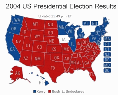
2004 U.S. Presidential Election Results
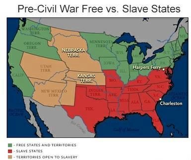
Pre-Civil War Free vs. Slave States
Origins: This is another example for which it is difficult to assign a value of "True" or "False" — there is a basic (and somewhat superficial) underlying fact which is true, but interpretations of that fact's significance are subjective and can be widely varied.
It is true that a map showing the locations of free and slave states (and territories) in the pre-Civil War U.S. bears a rough resemblance to a map showing the electoral vote results for the 2004 U.S. presidential election. Senator John Kerry won most of the states in the northeast, the Great Lakes, and the Pacific coast regions, while President George W. Bush captured all of the south plus most of the midwestern, western, and plains states. However, the similarities between these maps mask some very significant differences.
On the eve of the Civil War (which began in April 1861), the United States was very sharply divided along regional lines. Going into the 1860 campaign, the two major parties both essentially
split in two, each creating a northern and a southern wing. In the subsequent presidential election the northern Whig/Republican party (represented by Abraham Lincoln of Illinois) didn't even appear on the ballot in most southern states, and while the Southern Democratic party (represented by John C. Breckinridge of Kentucky) did make the ballot throughout most of the north, they rarely drew more than a relative handful of votes in those states. All four candidates captured at least one state's electoral votes, a rarity in U.S. election history.
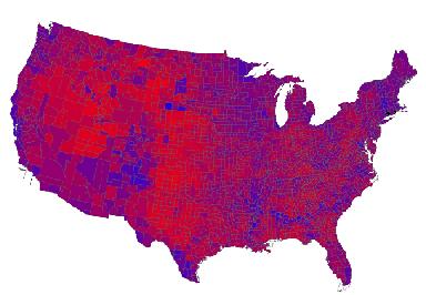
The electorate in 2004 was not nearly so sharply divided along regional lines, however — an electoral map just makes it appear that way because of the "winner take all" nature of the U.S. electoral system. Both the popular and electoral vote totals in 2004 were quite close (President Bush won the popular vote by a 51%-48% margin, and a single strongly-contested state such as Ohio could have tipped the electoral vote balance in the other direction), and although the states won by each candidate were largely clumped into regional clusters, both candidates generally ran very strongly even in the states they did not win. An election map with finer gradation (i.e., displaying results on a county-by-county basis rather than a state-by-state one, and providing color shading to reflect the closeness of the vote in each area) produces a better picture of how strongly both candidates in the 2004 election ran even in states which they lost:
According to exit polls and analysis of county-by-county election returns, the sharpest geographic distinction between the two candidates did not primarily correspond to region but to size of community: Senator John Kerry had a substantial 60%-39% edge in large cities (representing roughly 13% of the total U.S. population), while the reverse was true in rural areas (representing roughly 16% of the total U.S. population), where President Bush garnered a 59%-40% majority. What we saw in the 2004 election was more of an urban vs. rural division, regardless of state.
Last updated: 11 November 2004
Sources:
Alexander, Kate. "Election Officials Urge Voters to Check Ballots for Errors."
Austin American-Statesman. 23 October 2004 (p. B1).

 Sources: