
Skygazers in British Columbia were treated to a couple of spectacular views courtesy of an unusual cloud formation known as a "hole punch cloud."
According to Global News, the first hole punch cloud, also known as a fallstreak hole, appeared over the lower mainland on the morning of
A 'Hole Punch' cloud over British Columbia, today. Although there's a scientific reason for this, I prefer UFOs! pic.twitter.com/wTZH90Pjvo
Les Floyd (@Lesism) February 24, 2015
They're calling it a "fallstreak cloud", but I'm pretty sure it's Falcor, the Luck Dragon. https://t.co/kNVqKPGYuL pic.twitter.com/axZBX2hXMH
Sharon Holly (@dextermorganism) February 24, 2015
While some people resorted to their own imaginations to explain the strange cloud formations, the National Weather Service reported that fallstreak holes are not created by either UFOs or dragons:
What are they?
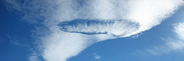
A fallstreak hole (also known as a "hole punch cloud") is a large circular or elliptical gap that can appear in cirrocumulus or altocumulus clouds.
How do they form?
High to mid level clouds, such as altocumulus, are often composed of tiny water droplets that are much colder than freezing, but have yet to freeze. These "supercooled" water droplets need a "reason" to freeze, which usually comes in the form of ice crystals. Planes passing through the cloud layer can bring these ice crystals.
Once the ice crystals are introduced, the water droplet quickly freeze, grow and start to fall. A hole is left behind, which will start to expand outward as neighboring droplets start to freeze.
While the people of British Columbia witnessed two fallstreak holes in one week, these cloud formations are not very common. Fortunately, several observers were able to capture some great photos and videos to document the rare event:
Last updated: 24 February 2015