
Because of Daylight Saving Time, the time zone difference is 20 hours for a part of the year.
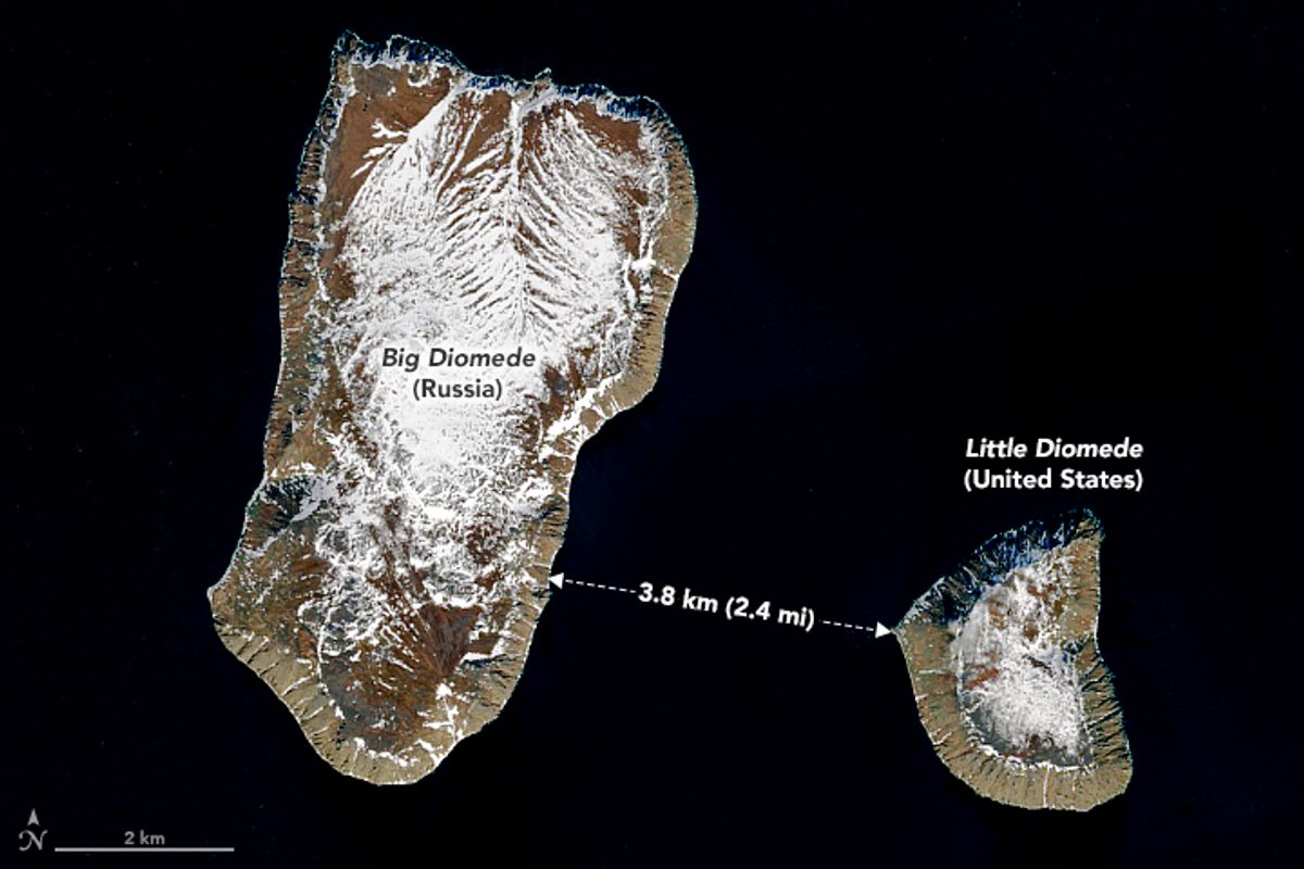
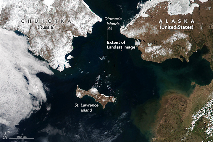
Located in the middle of the Bering Strait, the two islands known as Big and Little Diomedes belong to Russia and Alaska, respectively. An international date line and just under 2.5 miles separates the two remote, flat-topped landmasses, but they have a massive time difference.
A popular Reddit post shared on March 21, 2022, pointed out that the two Diomedes islands located between Russia and Alaska have a whopping 21-hour time difference.
This claim is true.
Nicknamed Tomorrow Island (Big Diomede) and Yesterday Island (Little Diomede), the sister islands make Russia the closest country to the continental U.S. without sharing a land border, notes NASA Earth Observatory. Russia’s Big Diomede Island is about 25 miles from Alaska, and thus the continental U.S.
As Earth Observatory reader Jim Andersen commented on a NASA blog: “When you look at the Big Diomede Island, you’re looking into the future!”
Little Diomede Island measures less than 3 square miles in size, while its larger neighbor is about four times larger. The two islands are divided by a maritime border that separates Russian waters from Alaska's. Little Diomede operates on Alaska Standard Time and Alaska Daylight Time (UTC/GMT -8 hours), while Big Diomede is on Anadyr Time (UTC/GMT +12 hours).
“The passage was historically nicknamed the “ice curtain,” which had more to do with Cold War tensions than climate,” wrote NASA.
A popular video shared to TikTok on March 26 also accurately noted that it is sometimes possible to walk 2.4 miles between the two islands during extremely cold months when the sea freezes, noted Alaska Centers.
With an estimated population of 119 people in 2020, Little Diomede makes up the 123rd largest city in Alaska.
Sources
Diomede, Alaska Population 2022 (Demographics, Maps, Graphs). https://worldpopulationreview.com/us-cities/diomede-ak-population. Accessed 25 Mar. 2022.
Earth Matters - January 2018 Puzzler. 23 Jan. 2018, https://earthobservatory.nasa.gov/blogs/earthmatters/2018/01/23/january-2018-puzzler/#comment-33415.
23 Jan. 2018, https://earthobservatory.nasa.gov/blogs/earthmatters/2018/01/23/january-2018-puzzler/.
How Close Is Alaska to Russia? | Alaska Centers. https://www.alaskacenters.gov/visitors-centers/faqs/how-close-alaska-russia. Accessed 28 Mar. 2022.
Iseman, Peter A. “Lifting the Ice Curtain.” The New York Times, 23 Oct. 1988. NYTimes.com, https://www.nytimes.com/1988/10/23/magazine/lifting-the-ice-curtain.html.
Jhon_August. “The Diomedes Islands Are between Russia and Alaska. The Two Island Are Less than 4 Km Apart but They Have 21h of Diference in Time Zone.” R/Interestingasfuck, 21 Mar. 2022, www.reddit.com/r/interestingasfuck/comments/tjlziu/the_diomedes_islands_are_between_russia_and/.
Yesterday and Tomorrow Islands. 27 Jan. 2018, https://earthobservatory.nasa.gov/images/91638/yesterday-and-tomorrow-islands?src=ve#:~:text=Just%203.8%20kilometers%20(2.4%20miles,Little%20Diomede%20Island%20(U.S.).