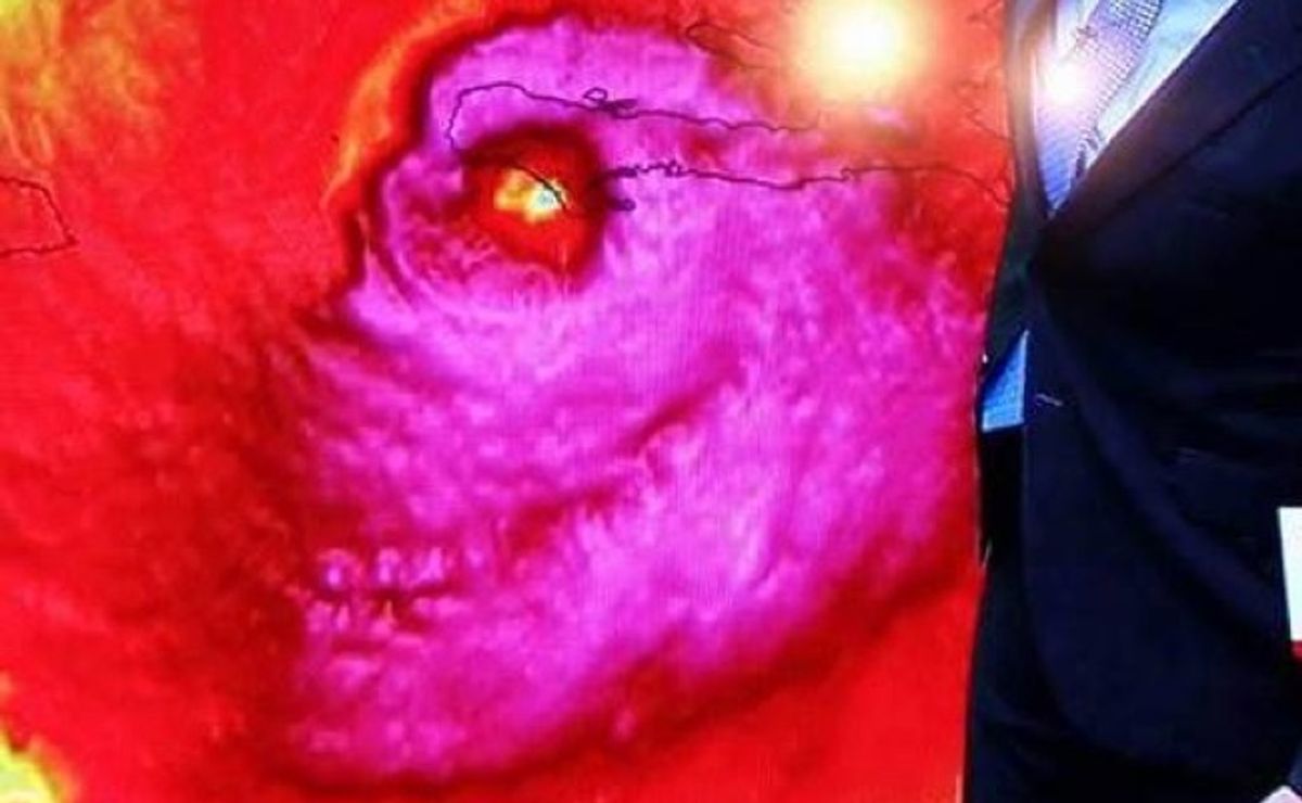
On 4 October 2016, Hurricane Matthew continued to make headlines. One particular satellite image of the storm caught the public's attention:
Frightening satellite image of #Matthew looking like a skull as it struck Haiti... https://t.co/87LzB8Ca9a
— Mark Stitz (@MarkStitz) October 4, 2016
Matthew made landfall on Haiti at approximately 7 a.m. local time, as a Category 4 storm:
#Matthew made landfall near Les Anglais, Haiti at 7 am EDT. This is the first Category 4 #hurricane landfall in Haiti since Cleo in 1964. pic.twitter.com/0Ux7qriWBn — NHC Atlantic Ops (@NHC_Atlantic) October 4, 2016
Reports out of Haiti were spotty, but early reports indicated significant damage:
Communication was difficult, and there was no confirmation of how many people were killed or injured. But initial reports from the country’s Civil Protection Force indicated that at least two people had died.
It was clear in phone calls with frantic residents in the south that they were coping with major devastation as the storm felled trees, ripped roofs and destroyed farms in what already was a struggling area in the Western Hemisphere’s poorest country.
Photographs appeared showing flooding after a possible storm surge and intense winds:
Rue Nicolas Geffrard
Les Cayes#MatthewHaiti pic.twitter.com/W9OZi8M4rR— Karl Lee Berlus (@Karlyhit) October 4, 2016
Heavy Winds in Les Cayes ! #HurricaneMatthew #MatthewHaiti #Haiti #MatthewsNewVid pic.twitter.com/gC6LWzRmEf — Val Adrien (@valadrien) October 4, 2016
During the coverage, the odd satellite map "skull" image appeared. Matt Devitt of southern Florida's WINK-TV was depicted alongside the satellite anomaly, and later took to social media to affirm that the image was authentic and unaltered:
SKULL OF MATTHEW: During my weathercast. This satellite image of Matthew's landfall is REAL. Freaky! Credit: @dewey_perez @CBSNews @CNN pic.twitter.com/EaFA3SSNRS — Matt Devitt (@MattDevittWINK) October 4, 2016
Hurricane Matthew's satellite skull image wasn't the first weather map to go viral on social media. The abstract shapes that appear in satellite images can look as though they represent many different objects, particularly to viewers with rich visual imaginations.
Previous maps caught the public's attention not for eerie undertones, but because of phallic imagery.